
Preserving & Expanding Climbing Access
Working with our partners at the Access Fund, Meadow River Valley Association, and other conservation organizations we are formalizing and even expanding climbing access around the New River Gorge Region. Below is more expansive information on these efforts as well as access updates to sensitive locations. Different land managers have different rules. Read below to stay up-to-date.
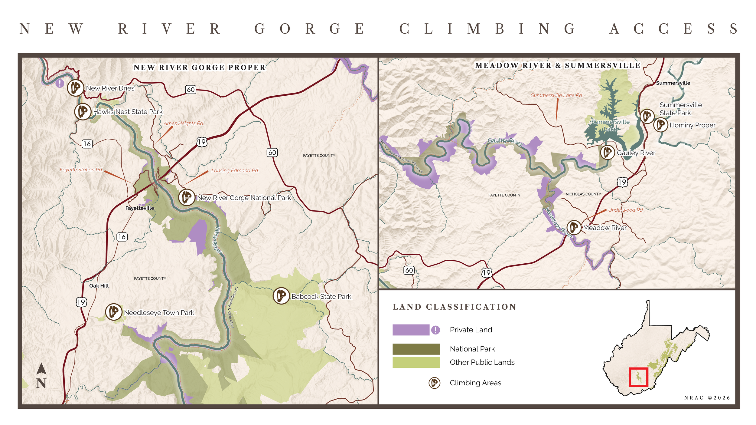
Know who’s land you are on, HERE on the WV Parcel Map. Expanded access details below.
-
SUMMARY: Climbing on NPS property in the New River Gorge is allowed! No new bolted route development is permitted.
This park, along with the Gauley River National Recreation Area, are managed by the National Park Service, headquartered in Glen Jean, West Virginia.
Rock climbing, including toproping, sport climbing, traditional climbing and bouldering, are allowed on National Park property. There are minimal restrictions specific towards climbing on established routes and boulders. There is a moratorium on development of new routes. Here are some special rules and restrictions that will be relevant to many climbers:
NO new bolted routes are permitted.
Replacement of existing bolts is by permit only, please see the bad-bolt reporting form HERE
From the NPS website: “Defacing, damaging, or altering the natural rock surface is prohibited.” SOURCE
From the NPS website: “The use of top anchors decreases impacts on cliff-top ecology. Please do not use tree trunks or other vegetation as anchors.”
It is illegal to cut down or injure a tree on U.S. Public lands. 18 U.S. Code § 1853.
Dogs are allowed but must be leashed.
It is frowned upon to move rocks and sticks for landings at the bottom of routes and landings for boulders. Minimize this when deemed important for safety.
Review the Superintendent’s Compendium for the New River Gorge National Park and Preserve. This document clarifies rules and regulations for all park visitors, including activity specific RULES.
-
SUMMARY: Climbing is informally allowed along the Dries, except Karnage Crag and Country Club are closed due to danger.
Management is primarily by Hawks Nest Hydro/Brookfield US. This includes Hawks Nest Dam boulders, Cotton Top boulders, CSX boulders and Cotton Hill routes.
Cotton Bottom boulders are managed by the WV Department of Natural Resources.
Hawks Nest Hydro/Brookfield US and WVDNR have been mostly hands off in management of climbing in these areas. As climbing is not yet formally recognized, there is always potential for jeopardized access, even if there have been no prior issues.
Hawks Nest Dam will vary the amount of water released based on precipitation, in addition to scheduled releases for rafting. Water releases can happen rapidly, causing the water to rise unpredictably. An increase in flow out of the dam is preceded by sirens. If you hear sirens, and are climbing at the water’s edge, be ready to make a quick retreat to higher ground.
Hawks Nest Hydro has asked climbers to NOT climb along the Dries below the surge basin and spillway. This includes Karnage Crag and Country Club. Much of this sector is HIGHLY dangerous for climbers, due to being immediately underneath and downstream of the spillway. The surge basin and spillway are a release point for the water tunnel, running from Hawks Nest Dam to the Hawks Nest Hydro Powerhouse by Cathedral Falls. A sudden drop in electrical needs from the powerhouse will shut off the generators and cause a water pressure backup, resulting in release of a LARGE amount of water out of the surge basin and down the spillway. Spillway releases are unpredictable, not controlled by the power company and have NO early-warning sirens prior to release. Water release and warning sirens are simultaneous. Due to the possible huge, rapid water releases, the potential is real for a dangerous flash flood along this section of the river. This contrasts to the releases at Hawks Nest Dam that are forewarned by sirens and done in a controlled fashion. Because of the danger, and along with the desires of Hawks Nest Hydro/Brookfield US, this area is closed.
-
SUMMARY: The Meadow River is almost entirely private property and mostly CLOSED to climbing, EXCEPT Lower Meadow routes and boulders and Meadow Top boulders. The only public land, part of the Gauley River National Recreation Area, is far downstream and has no good access without crossing over closed private property.
Southside:
SUMMARY: The Southside is CLOSED to all climbing.
Aka “River Left” Meadow River
From the start of the rail grade at Nallen, to the intersection with the rail grade along Glade creek, the 66 foot-wide, rail grade corridor is owned by Fayette County and is designated NON-MOTORIZED vehicles only. This has not been enforced as of early 2025, but there is the potential for the county to cite any motorized vehicle use.
From the start of the rail grade at Nallen, to the intersection with the rail grade along Glade creek, the property on either side of the rail grade is owned by Aurora. Aurora is a carbon-offset company and has not yet commented directly about climbing access on their property. They purchased this land from Heartwood Forestland Group, who previously asked us to NOT climb on this property. NRAC maintains that this closure remains in effect. Negotiations are underway for climbing access to this property as of early 2025.
Aurora also owns the Litz Roof boulders, and this cluster is similarly closed to climbing.
From Glade Creek, downstream to Dogwood Creek, the rail corridor and all of the land on either side is owned by Nuttall, LLC. This is CLOSED to climbing; the rail grade is also closed to all public access. Please DO NOT trespass. This closure includes, but is not limited to, the crags Mud Hueco, Area 51, the Pebble and The Other Place. Negotiations are underway for climbing access to this property as of early 2025.
Orange Wall is in the Gauley River National Recreation Area. HOWEVER, there is no current viable access without crossing over closed private property.
Upper Meadow:
SUMMARY: The Upper Meadow is CLOSED to all climbing.
AKA “River Right” Meadow River
Zero through Fourth Buttresses and the beginning of Cambodia are Nuttall, LLC property, and as such are CLOSED to climbing. Climbing on this property is trespassing.
The remainder of Cambodia and South Park are on Aurora property. However, there is no viable existing access without crossing through Nuttall, LLC or other private property.
Lower Meadow Routes and Boulders, Meadow Top:
SUMMARY: Climbing at the Lower Meadow and Meadow Top has not been formalized. It is okay to climb at these crags and boulders.
Meadow Top is privately owned. The owner asks for climbers to stay amongst the boulders and not wander up the hill on their property. They ask for NO FIRES.
Lower Meadow, both routes and boulders, have multiple owners. No contact has been established between NRAC and the landowners here. Please contact NRAC if you encounter the landowners or have their contact information.
Crags beyond/downstream of Sunkist wall are difficult to get to and have varying ownership with poor physical access. Please use caution when climbing at any of these crags, formalized access has not been established.
41 Boulders:
SUMMARY: Climbing at the 41 boulders should be limited, this is all private property with 3 different land owners, all without formalized access.
Wingman boulders are owned by private individuals. There has been no discussion with the landowners regarding access. Please limit your visitation here.
Surrounding the Wingman boulders property and starting just upstream of the Wingman boulder itself, is Weyerhauser property. This includes the Celebration boulders. Weyerhauser is the largest, private timber land holding company in the U.S. This property was up for sale in early 2024, the listing is no longer active, it is unknown if it sold or remains with Weyerhauser. Please limit your visitation here.
Golden Globe boulder is on the same property as the Celebration boulders, owned by Weyerehauser.
The Spiritual boulders are on property owned by Aurora. Please limit your visitation here.
Dogwood Cave:
SUMMARY: Dogwood Cave is CLOSED to climbing.
This is owned by Nuttall, LLC. Climbing here is also trespassing.
-
SUMMARY: Climbing at Summersville Dam Boulders is allowed. The Gauley Crag and Carnifax Ferry routes are on private property without formal access; it is okay to climb at these two crags. The remainder of the Gauley is physically challenging to access and has varying ownership.
The Summersville Dam Boulders are part of the Gauley River National Recreation Area (GRNRA) and managed by the National Park Service. Climbing is allowed here.
The only other documented boulders at Woods Ferry and Canyon Doors are also on GRNRA property.
Gauley Crag and Carnifax Ferry route climbing are both on private property. No formalized access has been established, however there have been no access issues. It is currently okay to climb at these crags.
The rest of the Gauley has varying ownership, between the GRNRA and private. There has been little established climbing of any type. Please contact NRAC directly for questions about climbing outside of the areas listed above.
-
SUMMARY: Climbing at Summersville Lake is allowed! Deep water soloing is allowed; falling is okay but jumping off the top of the cliff is PROHIBITED.
Summersville Lake is managed by the US Army Corps of Engineers (USACE). Nearly all climbing around the lake is on their property. NRAC has an excellent relationship with USACE and are encouraged to recreate on Corps land.
Access to much of the lake climbing is by way of Summersville Lake State Park (SLSP). There is a climber parking lot towards the back of the park, with overflow parking elsewhere in the park. There are a few boulders on SLSP property adjacent to the designated climber parking lot that we are allowed to climb on.
SLSP is managed by state employed staff, however there are privately managed concessions planned.
Other public access points to lake climbing include Whippoorwill and Long Point. Whippoorwill access crosses private property, there is a verbal agreement to allow this access. All access to Long Point is on Army Corps property.
Much of the lake is surrounded by private property, please use the known public access points for all climbing. Boating to boulders and routes is also possible.
Deep water soloing is allowed. It is unsafe to jump from the top of the cliffs, due to potential hazards in the water and danger from water impact. These dangers are mitigated when climbing from the water up, as knowledge of the landing zone is inherent. People are ticketed yearly by USACE for cliff jumping.
Route development is allowed, however please contact NRAC directly for information about route development on Army Corps property.
-
SUMMARY: Climbing at Needleseye is formalized and encouraged. Development is allowed!
Managed by the City of Oak Hill.
NRAC has signed a Climbing Management Plan, Memorandum of Understanding and Route Development Agreement to formalize climbing in the park.
Please visit HERE if you are interested in developing routes at Needleseye.
-
SUMMARY: Climbing at Babcock State Park and Camp Washington Carver is neither formally allowed or prohibited.
These parks are managed by state employed staff.
NRAC and the Access Fund are working with the local state parks to formalize access.
-
SUMMARY: Climbing is allowed and access is nearly formalized! A climbing management plan is under review by the State Park staff.
The park is managed by state employed staff.
NRAC encourages climbers to make use of State Park amenities including lodging and their on-site restaurant.
Route development will be allowed, however please contact NRAC directly for any questions about route development.
-
SUMMARY: This is mostly private property without formalized access. Please limit your visitation here.
Access and climbing involves use of property from multiple private landowners and the US Army Corps of Engineers.